The record
Document archive
Every document here is one anyone can obtain without being a member. The public records, from the City, the County Recorder or the Secretary of State — for a fee, and a wait. The governing documents, which every buyer of a unit here is handed before escrow closes. These are the same documents, free, so that a claim on this site can be checked against the paper it came from rather than taken on trust.
What is not here, and why
This is a curated list, not everything the coalition holds. One rule decides what goes on it: a document is published here if anyone could obtain a copy without being a member — because a public agency will sell it to whoever asks, or because it is one of the association’s governing documents, which the seller of any unit must hand to a prospective buyer under Civil Code § 4525(a)(1) and which the association must supply for that purpose under Civil Code § 4530. Council minutes, recorded maps, engineering plans and state filings pass the first test; the CC&Rs, Bylaws, Articles, Rules and Election Rules pass the second. Republishing them discloses nothing that is not already disclosed to anyone who asks — it only saves you the fee and the wait.
Documents that arrived in an owner’s mailbox do not pass it, and are not here at any resolution: assessment statements, notices, financial statements, correspondence with the management company. What those documents say is published — the figures, the dates, what a notice announced — on the timeline and throughout this site, each with its source named. The scan itself stays private, because publishing it would publish the owner who received it.
The rule is about what a copy discloses, not what the instrument is, and the governing documents show the difference. Every copy of them this site held until September 2026 came through a disclosure vendor and carried an order stamp naming the unit that bought it; those copies are still not published at any resolution. The copies here are the ones the managing agent serves to every owner on its portal, and the Election Rules are the copy it posts on its public page for this association — the same bytes. None names an owner. The transcriptions remain the better answer for reading and searching, and each links its scan from here.
Two things that look publishable and are not. The County Assessor’s map we hold is a commercial vendor’s export, so the County is the place to ask. Newspaper clippings are in copyright and belong to whoever wrote them. And a great deal the association distributes to its members — minutes, budgets, financial statements, the insurance certificate — is not here either, clean copies or not: the law gives those to members, and this site publishes what they say rather than the documents.
There is a great deal we simply do not have. Most of it is not rare — it is ordinary mail that one household kept and nobody else did, and there are 192 households here. What we are looking for lists it, and says what happens to anything you send.
The association’s governing documents
The five instruments this association runs on, in the managing agent’s own copies rather than a disclosure vendor’s: the Articles that incorporated it in 1971, the Bylaws adopted that December, the Restated Declaration of Restrictions recorded in 1977 and still in force, the Rules and Regulations revised in January 2011 with the notice that put them into effect, and the Election Rules adopted under SB 323. Each is also transcribed on this site for reading and searching; these are the scans the transcriptions were checked against.
Get your own copy: From the association: the seller of any unit must hand these to a prospective buyer (Civil Code § 4525(a)(1)), and the association must supply them to a selling owner within ten days of a written request (Civil Code § 4530). Every owner can download them from the managing agent’s owner portal, and the Election Rules are posted on its public page for this association. Any member may also request them as association records under Civil Code § 5200; the letter is on this site.
- Articles of Incorporation, with the 1977 Certificate of Amendment
The Secretary of State’s file for corporation 639925. Pp. 1–5 the Articles, endorsed filed November 29, 1971; p. 6 the notary’s acknowledgment of November 23, 1971 naming the five incorporators; p. 7 the Secretary of State’s certificate of August 24, 1977; pp. 8–10 the Certificate of Amendment endorsed August 18, 1977. A 2013 fax scan, image only.
- Bylaws of Jamacha Greens Homeowners Association
The Bylaws as adopted December 31, 1971, opening on the instrument’s own first page. Art. II § 2 defines a “majority of owners” as those holding 51% of the votes entitled to vote, which is why quorum here takes 98 of 192 and not 97. Scanned in 2010; the text layer is unverified OCR, so read the transcription for the words.
- Restated Declaration of Restrictions (the CC&Rs)
The declaration that governs today: the 1972 Declaration of Restrictions restated to fold in its annexations and amendments, recorded December 21, 1977 as File/Page No. 527902, Book 1977. P. 1 is the Government Code § 12956.1 fair-housing notice; pp. 2–42 the Declaration, ending in the consent and signature pages, on which M L M Investors alone signs for 93 units. Scanned in 2008; the text layer is unverified OCR, so read the transcription for the words.
- Rules and Regulations, revised January 2011, with the notice of approval
P. 1 is the management company’s letter of January 27, 2011 telling owners the Board had approved the revised Rules after a noticed meeting on January 20 and that they would take effect March 1, 2011. Then the manual: introduction, association and board, enforcement and the fine schedule, common area, signs, unit use, parking, pets, pool, noise, the January 2011 fine policy, the August 2010 satellite dish criteria, the ACH form, the architectural request form and a site map. A 2011 copier scan, image only.
- Rules for Elections and Voting
The election operating rules adopted under SB 323, citing Civil Code §§ 5100–5145 and 5200: equal access to association media, candidate qualifications and the grounds for disqualification, nominations, the inspector of elections, secret ballots, proxies and cumulative voting. The document carries no adoption date; August 18, 2020 is the day the PDF was generated, per its own metadata. This is the file the managing agent posts on its public page for this association, byte for byte.
City of El Cajon council records
Minutes, resolutions and ordinances from the meetings at which this development was prezoned, approved and built. The City serves these from its records portal.
Get your own copy: City of El Cajon, from the public records portal at elcajon.gov, at the copying fee the Public Records Act allows (Gov. Code § 7922.530).
- Regular Council Minutes, September 21, 1970
The prezoning hearing. Item 4 at pp. 5–6 takes Zone Reclassification No. 902 for McKeon Construction, to prezone the property on the east side of Jamacha Road from the County A-3(1) zone to the City R-3 zone. The Planning Director gives the density as 15 dwelling units per acre against a General Plan recommending 3 to 10. Carried 4–1.
- Regular Council Minutes, October 5, 1970
A general planning discussion at p. 19, in which the City Attorney describes the planned-residential-development ordinance — Ordinance No. 1718 of December 21, 1964, which he dates to 1963 — as one “which is yet to be used” and the Planning Director says “no one has ever used it”. Nothing else in it touches this property.
- Regular Council Minutes, December 14, 1970
Items 6 and 7 at pp. 5–8 are the hearings for Mollison Townehomes, McKeon’s other El Cajon project — not this one. They are here for one line: Frank Newberry’s fullest description of the condominium instrument McKeon used, and his note that he “requested rezoning on property on Jamacha first”.
- Regular Council Minutes, December 28, 1970
Item 23 at p. 22 adopts Resolution 575-70, approving El Cajon’s first planned residential development — at Chase Rancho, for McKeon Construction. Unanimous. Not this property; the precedent this one was approved under.
- Regular Council Minutes, January 25, 1971
The approval hearing for this development, items 4 and 5 at pp. 4–6: Planned Residential Development No. 2 and Tentative Map No. 177, “into 50 lots”. Newberry describes the association that would be formed, estimates the assessment at $12–$14 a month, and gives declarant control as six or eight months across three phases. Both votes unanimous.
- Regular Council Minutes, February 1, 1971
Resolution 36-71 at p. 24, approving Tentative Map No. 177 “and fixing improvements to be required therein”. Unanimous.
- Regular Council Minutes, August 23, 1971
Item 10 at p. 11 concerns a neighbouring improvement waiver, and records where Gustavo Street was to come from: the Director of Public Works states that “Gustavo is to be constructed through Jamacha Greens Development of the McKeon Construction Co. and it will deadend at the westerly line of the subject property with full improvements.”
- Resolution 538-71 — improvement contract
Approves the contract for improvement of the Jamacha Greens subdivision. The City Engineer estimates the improvements at $215,000.00; the inspection fee deposit is $6,450.00 and the lot staking bond $2,200.00. It recites that the subdivider wished to file the final map before the improvements were complete.
- Ordinance No. 2448 — the rezoning
The rezoning ordinance for Zone Reclassification No. 902, headed “(McKeon Construction Co.) P.R.D. #2”. Rezones portions of Lots 1, 2 and 5, Block 25, “S” Tract, Rancho El Cajon into Zone R-3-R, with four metes-and-bounds descriptions on p. 1. Adopted unanimously.
- Regular Council Minutes, May 9, 1972
A refuse-collection item at pp. 8–10 in which the City Manager distinguishes this development from McKeon’s other one: “the property is purchased by the townhouse owners and there is street frontage where the trash trucks can get through.”
- Regular Council Minutes, May 23, 1972
The same refuse matter concluded. The City Attorney describes the declarant arrangement at Mollison Townehomes — McKeon Construction “who is now the Home Owners Association until the property is sold out”. Said of that project, not of this one.
Recorded instruments and engineering plans
The instruments this development was created by, oldest first: the 1886 plat that laid out the blocks and lots, Gordon’s 1893 subdivision of six of them and the 1897 amendment of it, the 1940 road survey and the 1943 survey that name the families who held this ground between Gordon and the builders, the 1956 survey that carried the line forward, the subdivision map this association is described against, the March 1972 declaration that made it a condominium project, the condominium plans that drew every unit, and the improvement plans for its streets. Two copies of Map No. 7121 are published because they are not identical.
Get your own copy: Map No. 7121 from the San Diego County Recorder by File No. 271007, or from the County Surveyor’s Survey Records System; every survey plate here — Maps 355 and 830, Licensed Surveyors’ Map 44, Records of Survey 1096 and 4043, and Road Surveys 405 and 847 — from that same Survey Records System at srs.sandiegocounty.gov, by map number; the 1972 instruments from the Recorder by File/Page number, Book 1972, at $0.45 a document; the improvement plans from the City of El Cajon Engineering Department by drawing number.
- Map No. 355 — Resurvey and Plat of Tract No. 1, 1886
The oldest document about this land that anyone holds, and the sheet every later description is written against. One sheet: “Map of the Resurvey and Plat of Tract No. 1, being the south-west portion of plot ‘S’ El Cajon Ranch”, by O. N. Sanford, Surveyor, surveyed July 20 and filed July 24, 1886 by County Recorder S. A. McDowell. It lays out the numbered blocks and lots that every instrument since has cited — including the City’s 1972 rezoning ordinance, which puts Jamacha Greens on “portions of Lots 1, 2 and 5, Block 25” of it. Its Remarks block sets the pattern: regular lots 330 by 1320 feet and ten acres each, streets 66 feet wide except Broadway, Madison Ave and First Street at 90, and lots on the ranch boundary carrying their own dimensions instead. The last line ties the whole grid to a federal monument — “Post ‘C. No. 11’ indicates a corner No. 11 of the U.S. Official Survey of the El Cajon Ranch” — which surveyors were still working from in 1939. The sheet is a certified copy; the County Surveyor signs at the foot that it is a correct copy of the original.
- Licensed Surveyors’ Map No. 44 — Gordon’s Subdivision, 1893
Gordon’s subdivision as first filed, four years before the amended version below and drawn at twice the detail. One sheet: “A Subdivision of Lots 2, 3 and 4 in Block 25 and Lots 1, 2 and 4 in Block 26 of ‘S’ Tract”, by W. W. Allen at the request of J. T. Gordon, surveyed June 6 and filed August 2, 1893, at a scale of 200 feet to the inch against Map 830’s 400. Four lots — 21.52, 19.95, 14.75 and 19.62 acres — with Washington Ave. along the north and Jamacha Road along the west, all corners marked by posts three inches square and two feet long. The notary’s certificate on it is the earliest proof of Gordon’s ownership anybody has found: he appeared on the day of filing “known to me to be the proprietor of the land here subdivided”. The sheet dedicates nothing — there is no owner’s certificate offering a street to the public, so the roads on it are drawn as found.
- Map No. 830 — Gordon’s Subdivision, 1897
The survey this development still measures itself against, and for two years the oldest document in this archive — Map 355 and Licensed Surveyors’ Map 44, both above, are older, and this sheet is the amendment of the second of them. One sheet: “Amended map showing subdivision of a portion of Blocks 25 and 26 of S Tract … being part of Tract No. 1 of El Cajon Ranch … surveyed at request of J. T. Gordon, by W. W. Allen, Licenced Surveyor”, completed March 6 and filed March 18, 1897, at thirty minutes past five in the afternoon, by Gordon himself. Jamacha Road and the Road to Dehesa are on it, dashed, as roads his surveyor found already there. Galt Dr. and Bartram Way were added to the sheet later and are not part of the 1897 survey. The Basis of Bearings on the 1972 condominium plans points here: every bearing on this place is inherited from Gordon’s line.
- Road Survey No. 405 — Jamacha Road, south from Washington Ave.
The county’s survey of the road this development fronts, and the only sheet in this archive that names an owner against one of our own lot numbers. It begins “at the intersection of the Jamacha Road with Washington Ave in Rancho El Cajon and running thence South along the Range line between Range 1 East and 1 West” — that intersection is the north-west corner of Block 25, and the sentence says what Jamacha Road is: the line between two ranges, which is why land east of it is described in R.1 E. and land immediately west of it in R.1 W. Along the road it letters the owner of each parcel beside that parcel’s number. On this side: Wm Galbraith on Lot 1 of Block 25 and C H Williams on Lot 5 — two of the three lots Jamacha Greens was later built on. Opposite, in the other range: Geo Faquire, Christina Tibbetts, Chas S Judson, Harvey H Kessler, H E Decker and Nina, Fishburn, and W A Runnels & J Embree. Beside the centre line each owner’s deed is cited by Deed Book and page. And it draws what was standing, which a lot-line map never does — olive trees along the margin, a house, a garage, a lath fence, a syphon. The date is the one thing the sheet will not give up. Its Date cell is physically damaged; read from the original as May 1936 by Keith Pickering on September 13, 2026. Nothing else on the sheet dates it but a 1959 microfilm stamp, and County Surveyor E. R. Childs’ printed name brackets it loosely rather than fixing it.
- Road Survey No. 847 — the road across Block 25, 1940
A county road survey from R.S. 405 east to Vista Del Valle Boulevard, crossing a portion of Block 25 and Gordon’s Lots 2 to 6, in November 1940 under County Surveyor E. R. Childs. Plan above, ground profile below, with a typical roadbed section and a note to move existing fences to the new right-of-way line and protect the irrigation pipes during construction. What makes it worth republishing is the names. Eight households are lettered along the plan where the road passes their land — Williams, Kelly, Carbary, Freeman, Risinger, Doubleday, Boys — each with the book and page of their deed beside it. The half-century between Gordon’s 1897 plat and the suburb arriving is the thinnest stretch in the record of this place, and this one sheet puts nine households on the block.
- Record of Survey No. 1096 — Gordon’s Lots 1 and 2, 1943
The sheet that translates between the two ways this land is described. One sheet by H. L. Edwards, R.C.E. 1341, surveyed October 2, 1943 and filed April 6, 1944, covering Gordon’s Lots 1 and 2 “according to Licensed Surveyor’s Map No. 44. See also Map 830”. It draws Gordon’s lots over Map 355’s in dotted outline, so both numbering systems appear on one page, and its monument notes put the west boundary of Gordon’s subdivision on the east line of Block 25’s Lot 5 — measured 824.83 feet from Jamacha Road where the 1893 sheet letters 810. Edwards certifies that the owner who authorized the survey was C. C. Evernham. It also records that Gordon’s south line was already lost by then: “not recoverable… reestablished in this survey… corresponds with line of possession”.
- Record of Survey No. 4043 — Gordon’s Lots 1 and 2, 1956
The survey that carried Gordon’s 1897 line forward to the builders. One sheet by J. Edwin Dulin, Jr., L.S. 2460, surveyed on or about September 6, 1956 and filed October 16, dividing portions of Lots 1 and 2 of Gordon’s Subdivision into sixteen parcels of about an acre each. Its header reads “See also Map 830, GORDON’S SUBDIVISION”, and the drawing is captioned with that name. Dulin certifies that the owner who authorized the survey was the Coker Binswanger Company. The line it drew matters more than the parcels: the Basis of Bearings note on the Phase 1 condominium plan of 1972 reads “a portion of the westerly line of Lot 2, portion of Blocks 25 and 26 of ‘S’ Tract, Map 830, commonly known as Gordon’s Subdivision, as shown on Record of Survey 4043” — so every bearing drawn for this development starts from the west edge of the ground on this sheet, and a surveyor in 1943 had already set three pipes down that same line. Washington Street, 3rd Street and Jamacha Road run along its margins.
- Improvement Plans, City Drawing No. 2440
Seven sheets by Rick Engineering for Jamacha Road, Gustavo Street and Amistad Court, El Cajon job 992. The sheet-1 title block carries the construction record — started 10-20-71, completed 8-7-73, contractor Nelson, inspector R. Piete — and the drawing is stamped AS BUILT 11/19/73. The City Engineer signed it 10/4/71. The WORK TO BE DONE list includes the construction of survey monuments to City standard FS-302.
- Map No. 7121 — the subdivision map (City of El Cajon copy)
The recorded map this association is described against — the Bylaws and the Articles both describe the property as Lots 1 through 6 of it. Five sheets, surveyed September 1970 by William B. Rick R.C.E. 9416, recorded as File No. 271007 at 3:20 P.M. This is the City’s print, and it carries hand marks the County Surveyor’s copy does not: AMISTAD PLACE struck out of the City Clerk’s acceptance on sheet 1, and the southern loop relabelled AMISTAD COURT on sheet 4. Both prints carry the Recorder’s endorsement, so the marks were made after recording.
- Map No. 7121 — the same map (County Surveyor copy)
The same five sheets from the San Diego County Surveyor’s Survey Records System, carrying none of the City copy’s ink: the City Clerk’s certificate reads with nothing struck, and sheet 4 labels the loop AMISTAD PLACE. Published beside the City’s print because neither one on its own is the whole story of what was accepted and what was changed afterwards.
- The founding instrument — File/Page No. 80367, Book 1972
What made this a condominium project, recorded at 4:21 P.M. on March 31, 1972 and never republished anywhere since. Forty-eight pages in one recording. The Declaration of Restrictions runs to p. 15 and is signed “McKEON CONSTRUCTION, A California corporation, By Frank Newberry, Vice President” over the company’s embossed seal — the first document the coalition holds in which McKeon Construction states what it legally was. Behind it, as recorded attachments, are the Articles of Incorporation signed by five incorporators on November 23, 1971, the Bylaws in their original twenty pages, a certificate of consent covering Lots 1 through 6, and the condominium plan for Phase 1 — index map, floor plans, elevations and every unit number. This is the Recorder’s own copy and carries no vendor watermark.
- File/Page No. 80368 — the plans for Phases 2, 3 and 4
The drawings for the other three-quarters of the development, recorded the same afternoon as No. 80367. Ten sheets: an index map for each phase with its lots shaded, floor plans and sections, and a site plan numbering every unit. Nearly every deed in this development cites one of these two numbers — a unit’s legal description names the plan its air space is drawn on — so this is the sheet a reader needs to see their own unit as the county sees it. Two things about the copy, which is the Recorder’s: the Phase 3 index map is scanned twice, and the instrument’s own first page is missing from it, so what is published here begins at a notary acknowledgment. That missing page is why this entry is titled by its file number rather than by a document name — the County’s index calls No. 80368 a Declaration of Annexation, the eleven pages that arrived are plans, and the page that would settle which is the one that did not come.
California Secretary of State filings
What the association tells the state about itself. These are the only record of its own governance we hold between the 1977 charter amendment and the September 2023 disclosure packet.
Get your own copy: California Secretary of State business search, entity 0639925, which serves the filing images free.
- Statement by Common Interest Development Association, 2021
Form SI-CID for entity C0639925, naming the managing agent, the development’s location by street, the type as a condominium project and the number of separate interests as 192. Item 5, the president’s block, is blacked out by the Secretary of State before release — Civil Code § 5405(f) makes that block available only to named state officials on written request.
- Statement by Common Interest Development Association, 2023
The same form and the same substance as the 2021 statement, with the president’s block again blacked out by the Secretary of State. Signed and dated fifteen months before its April 2023 filing date.
- Statement of Information, 2024
File BA20241022469. Names two officers — Greg Atherton as Chief Executive Officer and Ambert Fish-Madison as Secretary and Chief Financial Officer — both at the managing agent’s office, with Kenneth Pernicano as agent for service of process.
The condominium plans
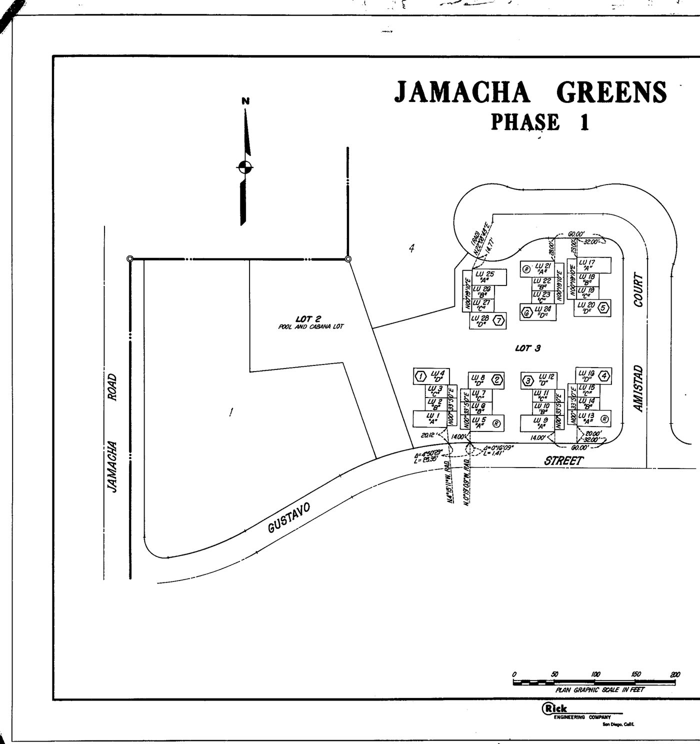
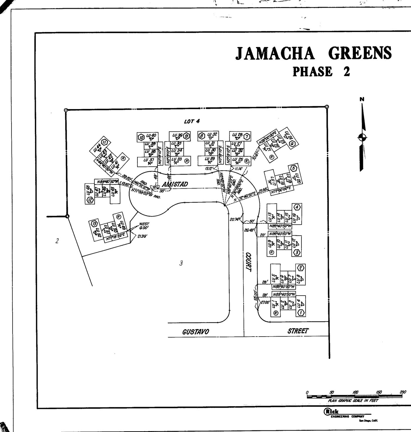
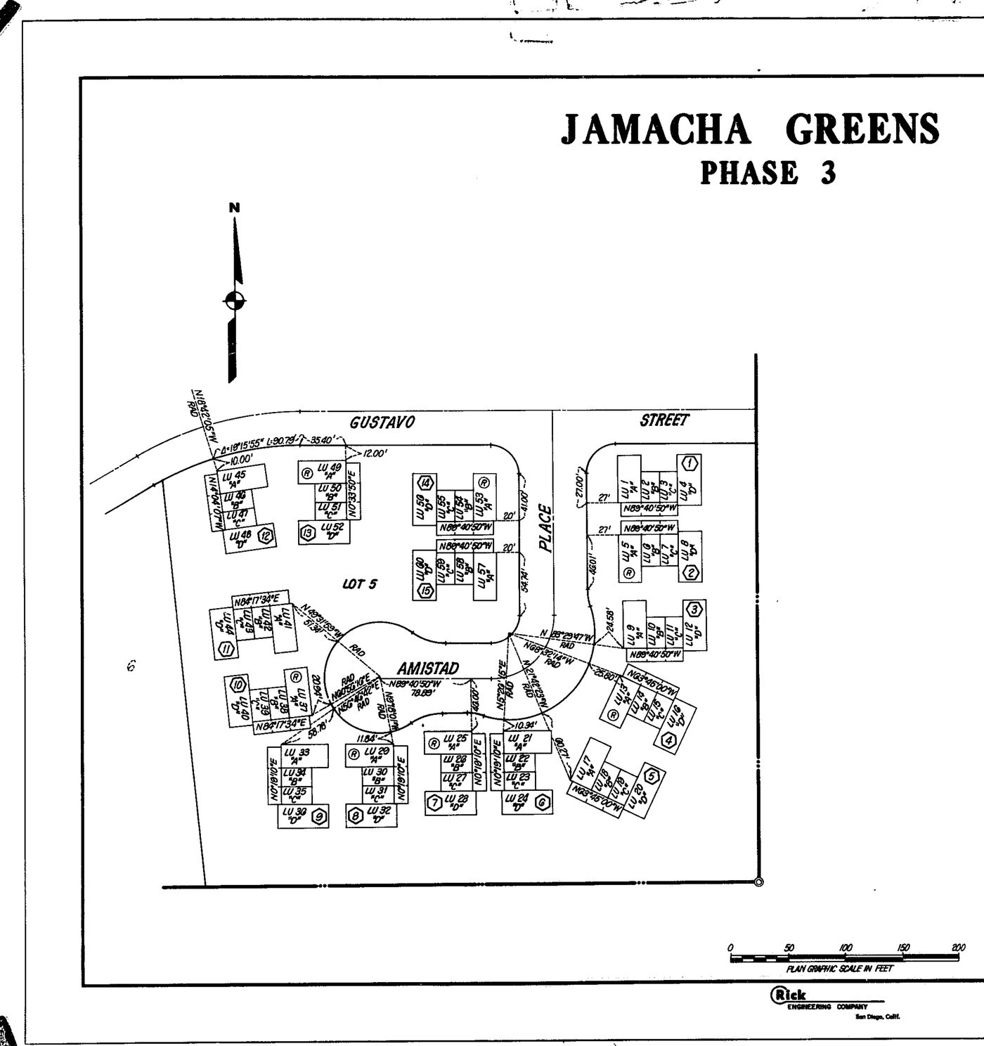
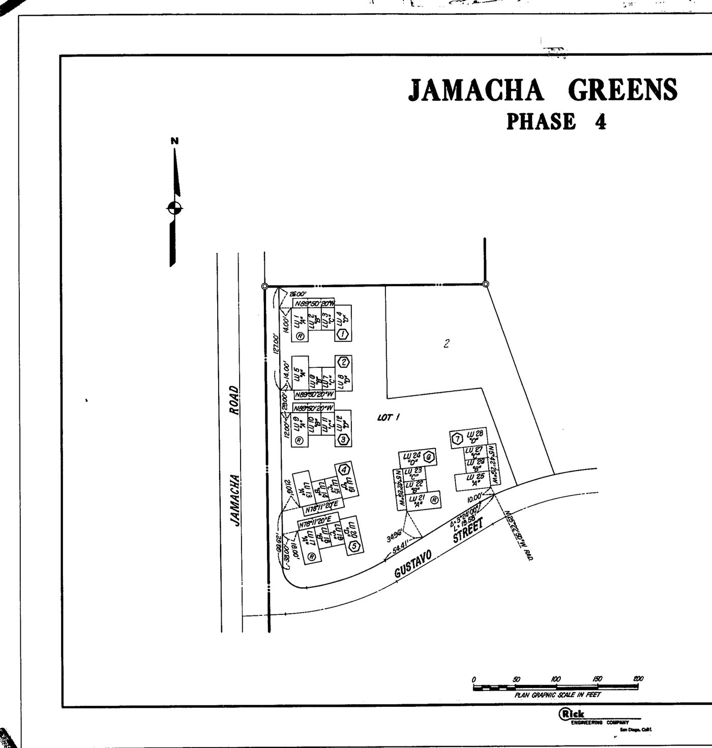
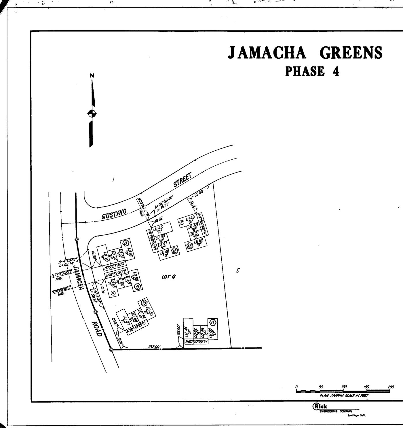
These five drawings are inside the two 1972 instruments above — three sheets at the back of File/Page No. 80367 and ten more in No. 80368. They are the only drawing of this place that numbers a reader’s own building and unit, and they are reproduced here because a link to a forty-eight page scan is not the same as being able to look at them.
A deed here is written against one of these sheets. The 2023 grant deed for 931 Jamacha Road Unit A describes what it conveys as “the air space within the living unit designated by Unit No. 09, in Lot 1 (Phase 4) … on that certain Condominium Plan, recorded as File No. 80368”. That unit number is drawn on the fourth sheet below; the phrase in the deed and the hexagon on the drawing are the same thing.
They also count the place. Read off the building tables, the five lots carry 7, 13, 15, 7 and 6 buildings — forty-eight in all, of four units each, which is 192. Those five figures are also the five denominators the County Assessor writes against each phase on its map of this development: 1/28 for Lot 3, 1/52 for Lot 4, 1/60 for Lot 5, 1/28 for Lot 1 and 1/24 for Lot 6. The Assessor’s fractions are the per-lot unit counts, which nothing until now had shown.
The plans themselves do not divide Phase 4 that way, and an owner there should know it. Note 4 on each sheet gives the undivided interest in Common Area “A” as 1/28 in Phase 1, 1/52 in Phase 2, 1/60 in Phase 3 — and 1/52 in Phase 4, which is its two lots pooled (28 + 24). So the plan gives a Phase 4 owner one fraction across both lots where the Assessor writes two, one per lot. They may well be measuring different areas rather than contradicting each other, and this site is not going to guess which: it is recorded here because the number decides a share of the common area, and a reader is entitled to know the two sources differ.
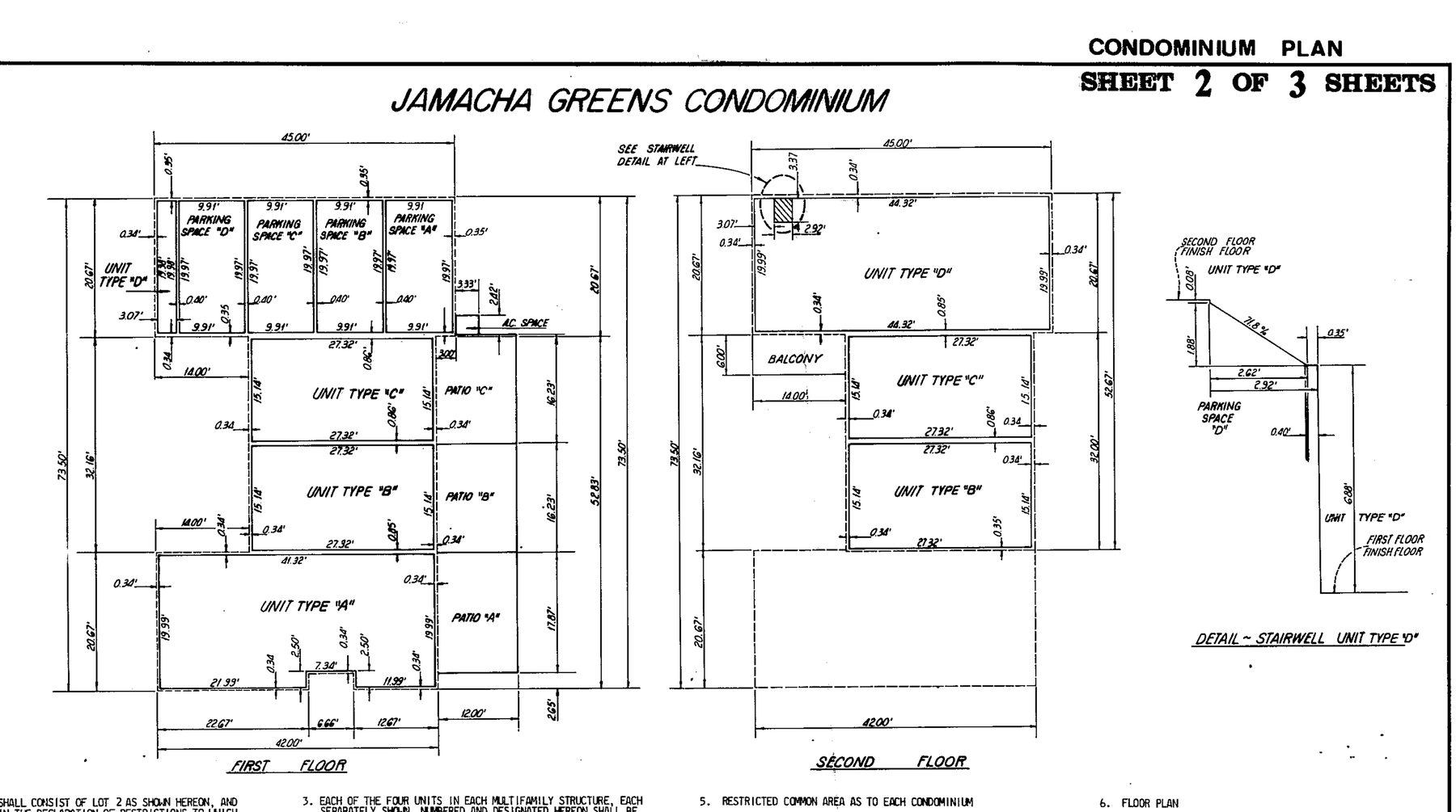
Where your unit ends is on this sheet, in note 3, and it is the answer to most arguments about who repairs what. A unit is “the space bounded by and contained within the interior surfaces of the perimeter walls, floors, ceilings, windows and doors”. What is not part of it: “bearing walls, columns, floors, roofs, foundations, reservoirs, tanks, pumps, and other central services, pipes, ducts, flues, chutes, conduits, wires, and other utility installations, wherever located, except the outlets thereof when located within the units”. So the pipe in your wall is not yours and the socket on it is.
Note 5 says which patio and which parking space go with which unit, as “restricted common area” — common area set aside for one unit’s exclusive use, not owned outright. Type A takes Parking Space “A” and Patio “A”; B and C the same with their own letters; and Type D takes Parking Space “D”, the balcony, and the space occupied by the air-conditioner condenser, which the sheet designates “A.C. Space”.
The sheet also carries the builder’s own address block — “Surveyed and subdivided for: McKeon Construction, 3435 Camino Del Rio South, Suite 122, San Diego, California 92120” — and note 6, which explains that a plan marked “R” is this one reversed, for the buildings that face the other way.
There is a great deal more
The 31 documents above are the ones this site cites. Behind them sit several hundred more — council minutes going back to 1965, and a continuous run of building permits on this property from 1972 to 2024 that no summary of this place had ever drawn on. Most of the council files say, in effect, nothing about this property, which is worth knowing and is why they were read.
If you are looking for something specific and it is not here, ask — it may already be sitting in the archive unpublished, and if it is not, the City’s portal and the County Recorder are open to you exactly as they are to us.