Your deed describes this place in the language of a survey made in 1886, by a man working with a chain and a transit on ground that had no El Cajon in it yet. Nothing about that language has been retired since. The City’s 1972 rezoning ordinance calls Jamacha Greens “portions of Lots 1, 2 and 5, Block 25, ‘S’ Tract, Rancho El Cajon” — and Lots 1, 2 and 5 of Block 25 are boxes O. N. Sanford drew on a sheet of paper eighty-five years before the first foundation went in.
This page is about those eighty-five years.
1886: somebody draws the boxes
Sanford’s map is titled “Map of the Resurvey and Plat of Tract No. 1, being the south-west portion of plot ‘S’ El Cajon Ranch”. He finished the survey on July 20, 1886 and the County Recorder filed it four days later.
Its Remarks block is the whole plan in five sentences. Regular lots are 330 feet wide by 1,320 feet long and contain ten acres each, except a tier on the south side of First Avenue that gets half that. Streets are 66 feet wide, except Broadway, Madison Ave and First Street, which are 90. Lots along the edge of the ranch are irregular and carry their own dimensions on the drawing — and Block 25, where we are, is one of those edge blocks, so its lots are not the tidy ten-acre rectangles the rest of the sheet is made of.
Then the last line, which is the one worth keeping:
Post “C. No. 11” indicates a corner No. 11 of the U.S. Official Survey of the El Cajon Ranch.
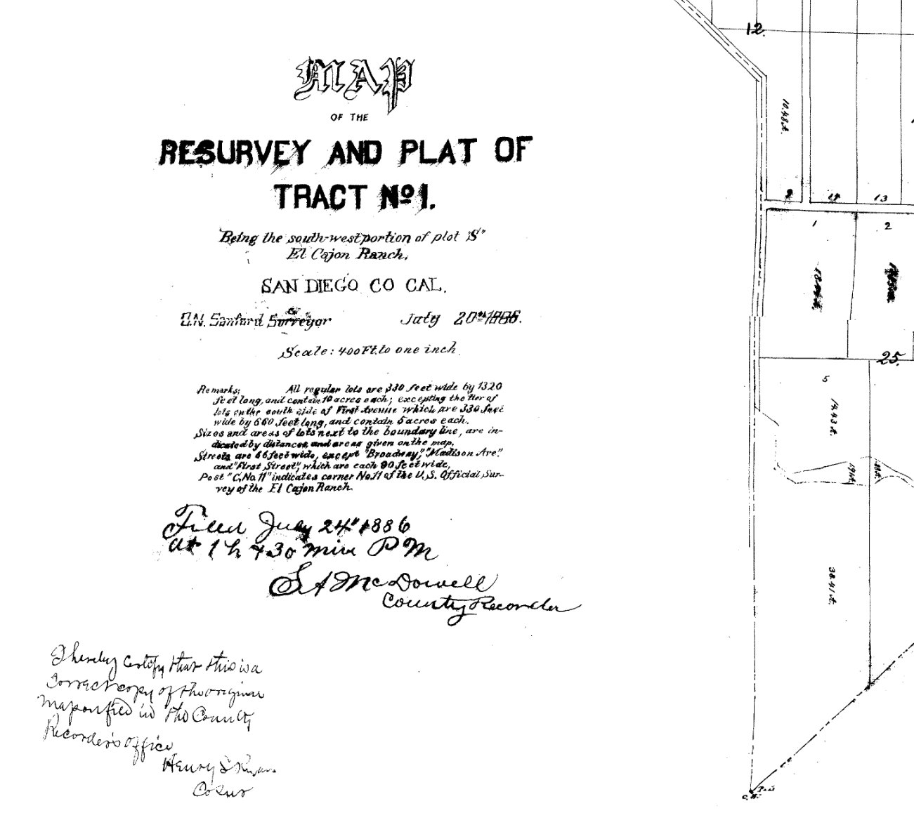
A single wooden post, tied to the federal survey of the Mexican land grant underneath all of this. Surveyors were still finding that post and measuring from it sixty-six years later — a 1952 record of survey lists eight separate sheets that describe the same corner. It is the bottom of the stack. Nothing beneath it is a subdivision at all.
1893: J. T. Gordon puts his name on it
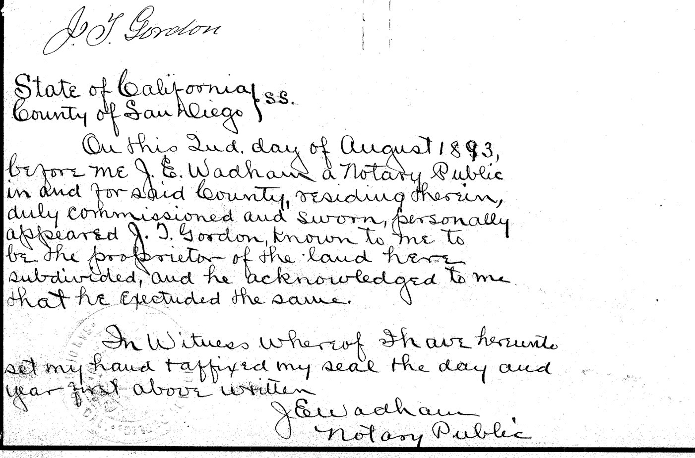
Seven years on, a surveyor named W. W. Allen laid out a subdivision of six of Sanford’s lots at the request of J. T. Gordon, and Gordon walked into the Recorder’s office on August 2, 1893 to file it himself, at forty minutes past one in the afternoon.
The notary’s certificate on that sheet is the earliest hard evidence of who owned any of this ground:
…personally appeared J. T. Gordon, known to me to be the proprietor of the land here subdivided, and he acknowledged to me that he executed the same.
Allen came back four years later and redrew it — Map No. 830, “Amended”, March 1897, same surveyor, same owner, eight lots where there had been four. That 1897 sheet is the one later surveys keep pointing at, and the name stuck to the ground: engineers were still captioning their drawings “Gordon’s Subdivision” in the 1950s, sixty years after he filed it.
Two things about those sheets are easy to miss. Gordon’s survey dedicated nothing — there is no owner’s certificate offering a street to the public, so Jamacha Road and the road to Dehesa are drawn on them as roads that were already there. And by 1943 his lines were already going missing: a surveyor retracing them that year wrote that the south line of one lot was “not recoverable” and had to be re-established from the fence people had been treating as the boundary.
The 1930s: Galbraith on Lot 1, Williams on Lot 5
The County surveyed Jamacha Road itself as Road Survey No. 405, beginning, in its own words, “at the intersection of the Jamacha Road with Washington Ave in Rancho El Cajon and running thence South along the Range line between Range 1 East and 1 West.”
That intersection is the northwest corner of Block 25 — our corner. And the sentence explains something that otherwise looks like a clerical error in half the paperwork about this place: Jamacha Road runs along a range line. Land east of it is described in Range 1 East, land west of it in Range 1 West, which is why two neighboring parcels off Jamacha Road can carry township descriptions that look nothing alike.
That range line has a name. Ranges are counted east and west from a principal meridian, so the line dividing Range 1 East from Range 1 West is the meridian — here the San Bernardino Meridian, the line every township and range in this part of California is numbered from. It is lettered by name, in those words, down the west edge of both the 1938 and 1939 surveys below, running beside Jamacha Road at a bearing of N 0°11′20″ E.
The sheet letters the owner of every parcel it passes, beside that parcel’s lot number. On our side of the road:
- Wm Galbraith — Lot 1, Block 25
- C H Williams — Lot 5
Two of the three lots Jamacha Greens now stands on, with a name on each. Across the road, in the other range: Geo Faquire, Christina Tibbetts, Chas S Judson, Harvey H Kessler, H E Decker and Nina, Fishburn, and W A Runnels & J Embree.
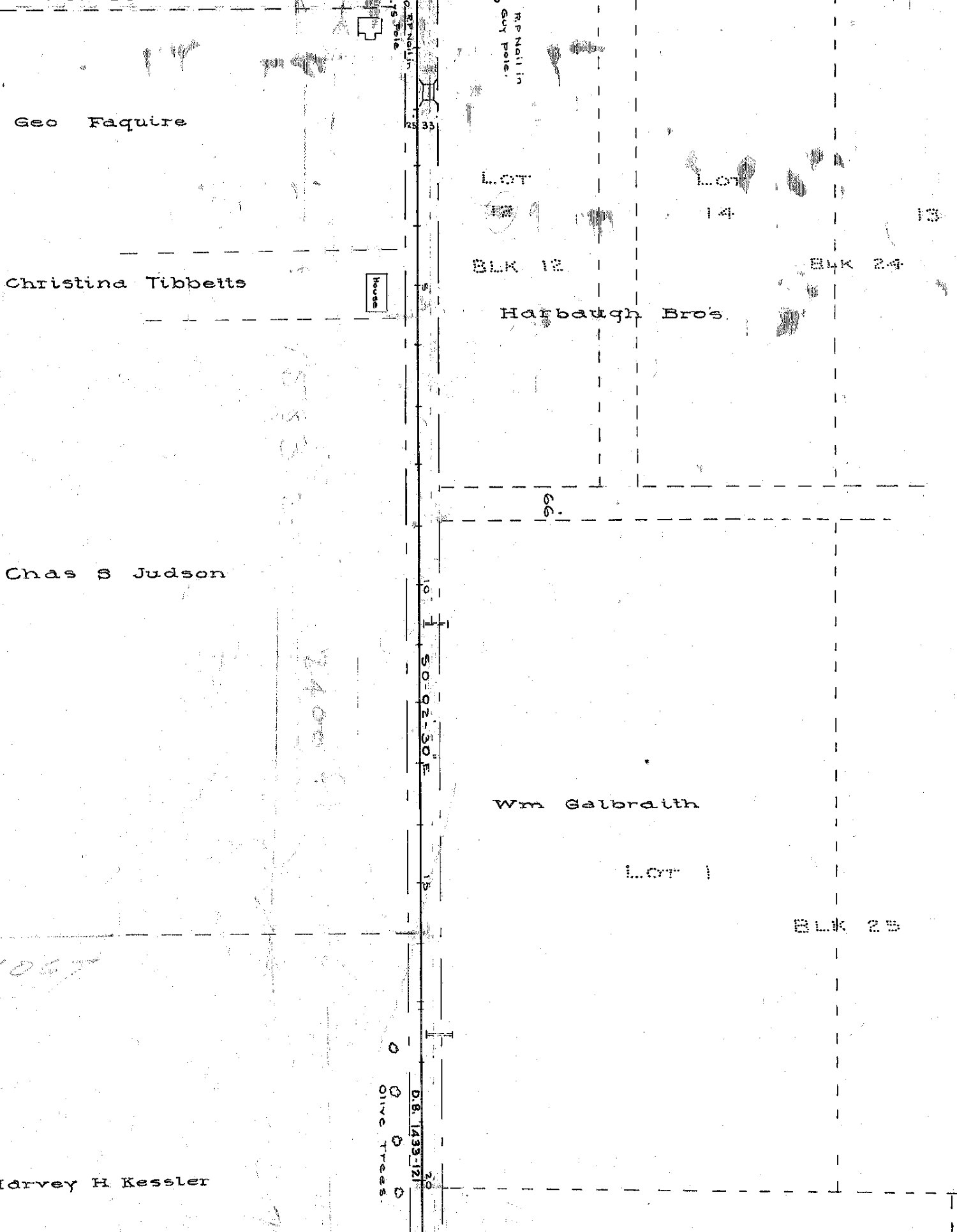
It also draws what was standing, which a lot-line map never does — olive trees along the road margin, a house, a garage, a lath fence, a syphon, the guy poles the surveyor drove his reference nails into.
Two more surveys of Lot 5 come out of the end of that decade, and they were made for ordinary reasons — a bank in one case, a landowner in the other.
In December 1938 the First National Trust and Savings Bank had Norman O. Glover survey “the South 19.75 ± acres of lot 5, block 25” — the bottom end of the lot, where it runs down toward Vista Del Valle. Three names are lettered on the ground he drew: Frankenstein, holding 7 acres, Berg, and Love.
Seven months later, in July 1939, Chas. M. Williams brought the same surveyor back for a portion of the same lot. That sheet fixes the northeast corner of Lot 5 — a ¾-inch iron pipe, found rather than set — and splits its ground four ways: Williams himself on the large western piece, Earl A. Williams on 1.94 acres, E. A. Williams on 1.42, and H. G. Haythe on 0.92.
The Williams name is on Lot 5 across all three sheets, and the middle initial is different every time — C H on the 1936 road survey, Chas. M. in 1939, Charles N. in 1940. That is worth noticing rather than settling. A family dividing ground among itself produces exactly that pattern, and so do three draftsmen reading the same handwriting.
1940: nine households on one road
Five years later the County ran Road Survey No. 847 east from that road, over a corner of Block 25 and across Gordon’s lots, and lettered the abutting owners again, each name carrying the book and page of that owner’s deed.
Charles N. and Bertha A. Williams and Earl and Marqray Williams appear at the same book and page, which is one instrument conveying to both couples: a family splitting a piece of ground between them. Beside them, Chas. F. and Rosemary C. Kelly, James and Ruth Carbary, Geraldine L. Boys, Mervin K. and Lois Freeman, C. L. and Loretta Risinger, and Louise C. Doubleday.
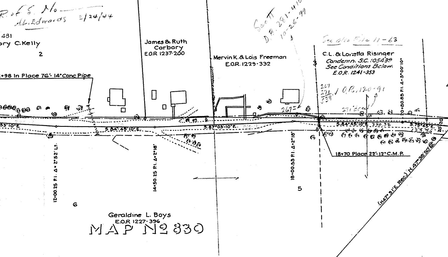
The sheet is a road plan, so it also carries a ground profile and a construction note about moving existing fences to the new right-of-way line and protecting the irrigation pipes while the work went on. That is what this was in 1940: irrigated smallholdings with a county road being widened through them.
1943 to 1956: the names change faster
- 1943. C. C. Evernham has H. L. Edwards survey Gordon’s Lots 1 and 2. Edwards sets three pipes down the line that separates Gordon’s ground from Block 25’s Lot 5, and measures 824.83 feet from Jamacha Road to the top of it — against the 810 feet Allen had lettered there in 1893. Fifty years apart, fifteen feet.
- 1952. Cora Northway and Louise Doubleday — the same Doubleday named on the 1940 road survey — have a portion of Gordon’s Lots 3 and 4 surveyed. Twelve years is a long time to hold farm ground and be able to prove it.
- 1954. Pierre J. Van Zweden has Ivan L. Nolan survey a portion of Lot 5, Block 25 into parcels of about two acres. Nolan notes that the northwest corner of Lot 5 had nothing on it: “Nothing found. Set ¾” I. Pipe.”
- 1956. The Coker Binswanger Company has J. Edwin Dulin, Jr. divide portions of Gordon’s Lots 1 and 2 into sixteen parcels of about an acre each, with Washington Street, 3rd Street and Jamacha Road along the margins.
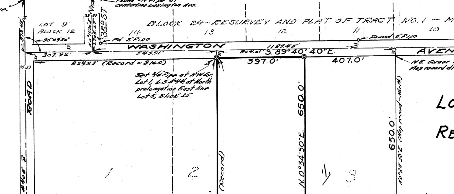
Ten-acre farms in 1886. Two-acre pieces in 1954. One-acre parcels in 1956. Nobody had to announce that the valley was turning into a suburb; the survey plates say it on their own.
One of the roads Dulin reserved in 1956 did get built — half of it, anyway. His sheet
letters EASEMENT RESERVED FOR ROAD across the ground he divided, thirty feet each
side of a center line. Fifteen years later, when Rick drew the street plans for this
development, he lettered the far end of Gustavo Street where it runs out to our
boundary: PAQUITA STREET — 60′ ROAD EASEMENT PER R.O.S. 4043, fourteen feet of
parkway, thirty-two of pavement, fourteen more. It was already surfaced by then — his
note says the six inches of asphalt on it went down under an older set of plans — with a
manhole to bring up to grade and a fence to pull out where our curb was going in.
And it stayed an easement. In February 1978 the City’s Director of Public Works, John Pizzato, put it to the Council in as many words: “Paquita is a 60 foot easement road and the ownership goes to the centerline of the street.” The appeal being heard that night failed because the zoning ordinance requires a lot to front a dedicated City street, and Paquita was “an unimproved non-dedicated street.” Eight months later a neighbor along it told the Council why nobody was in a hurry: “Paquita Street is about one-half block… At this time they are not interested in putting in a street, even if it were free because they have a nice private situation there.”
Twenty-two years after it was reserved, half a block of it existed and the people on it wanted it left that way.
1970: the last subdivision
In September 1970 William B. Rick surveyed the five sheets that became Map No. 7121, recorded November 19, 1971. The City rezoned Lots 1, 2 and 5 of Block 25 on February 1, 1972, and what went up on them is the place you live in. That story — the company, the fourplex, what the builder told the City Council it would cost — is the next page.
Lot 5 did not all come here. Sunrise Shadows, immediately south of us, is a subdivision of another portion of the same lot, recorded in 1980 — so the boundary between us and our neighbors down there is a line inside a box Sanford drew in 1886.
That line has now been measured twice, seven years apart, by two surveyors who never worked together. Rick lettered it on Map 7121 as N 89°40′50″ W, 742.81 feet. In March 1979 Phillip S. Butcher, surveying Sunrise Shadows, found two of Rick’s own monuments at either end of it and measured N 89°40′40″ W, 742.93 feet — ten seconds of bearing, and 0.12 of a foot, about an inch and a half, over seven hundred and forty-two. Both figures are lettered on Butcher’s sheet one above the other, which is how a surveyor shows his work.
What is still missing, and why
There is a hole in the middle of this, and it is worth naming rather than papering over.
The San Diego County Recorder’s online index of deeds reaches back to about 1970. Everything above comes from survey plates instead, because a record of survey states who commissioned it, and the survey series has no such floor — that is the whole reason this page can name anybody at all before McKeon.
What survey plates cannot give is the transfers. A map names who held a parcel on the day it was drawn; a deed names who sold it, who bought it, and when. Road surveys 405 and 847 cite those deeds by book and page — a dozen of them between the two sheets — and none has been ordered yet. Until they are, this page can say that Galbraith held Lot 1 and that Williams held Lot 5, and cannot yet say who either of them bought it from.
Sources 16
- Map No. 355, "Map of the Resurvey and Plat of Tract No. 1, being the south-west portion of plot 'S' El Cajon Ranch", O. N. Sanford, Surveyor; surveyed July 20 and filed July 24, 1886 by County Recorder S. A. McDowell. The sheet held is a certified copy. San Diego County Surveyor's Survey Records System (srs.sandiegocounty.gov) by map number, or /archive
- Licensed Surveyors' Map No. 44, "A Subdivision of Lots 2, 3 and 4 in Block 25 and Lots 1, 2 and 4 in Block 26 of 'S' Tract", W. W. Allen at the request of J. T. Gordon; surveyed June 6 and filed August 2, 1893, acknowledged the same day before notary J. E. Wadham. Same source; also /archive
- Map No. 830, the amended map of the same subdivision, W. W. Allen for J. T. Gordon; completed March 6 and filed March 18, 1897. Same source; also /archive
- Road Survey No. 405, County of San Diego, "Beginning at the intersection of the Jamacha Road with Washington Ave in Rancho El Cajon and running thence South along the Range line between Range 1 East and 1 West"; Field Book 101, County Surveyor E. R. Childs. The Date cell is damaged; read from the original as May 1936 by Keith Pickering, September 13, 2026. Held at docs/city-records/ and indexed at docs/city-records/MANIFEST.md
- Road Survey No. 847, County of San Diego, from R.S. 405 easterly to Vista Del Valle Boulevard, crossing a portion of Block 25 and portions of Lots 2 to 6 of Map No. 830; Book 101, November 1940, County Surveyor E. R. Childs. Same source; also /archive
- Record of Survey No. 710, "the South 19.75 ± acres of lot 5, block 25 of the 'S' tract, Rho. El Cajon, County Recorder's map No. 355", together with a portion of Lot 6 per Map No. 830 and of Lots 5 and 6, Section 18, Township 16 South, Range 1 East; surveyed at the request of The First National Trust and Savings Bank in December 1938 by Norman O. Glover, Licensed Surveyor No. 1880; File No. 369, filed January 4, 1939. Held at docs/city-records/ and indexed at docs/city-records/MANIFEST.md
- Record of Survey No. 750, a portion of Lot 5, Block 25, surveyed at the request of Chas. M. Williams on July 13, 1939 by Norman O. Glover, Licensed Surveyor No. 1880; File No. 34299, filed July 22, 1939. Same source
- Record of Survey No. 1096, Gordon's Lots 1 and 2 per Licensed Surveyor's Map No. 44, surveyed for C. C. Evernham October 2, 1943 by H. L. Edwards, Registered Civil Engineer No. 1341; File No. 24655, filed April 6, 1944. Same source; also /archive
- Record of Survey No. 3025, a portion of Gordon's Lots 3 and 4, surveyed for Cora Northway and Louise Doubleday on or about March 27, 1952 by Albert W. Daniels, L.S. 2201 of Daniels & Brown; File No. 36686, filed March 17, 1953. Its monument note at Corner No. 11 of the El Cajon Rancho lists eight sheets describing the same post: L.S. 422, R.S. 405, L.S. 457, R.S. 322A, R. of S. 710, 720, 2703 and 3010. Preview copy read September 13, 2026; the full sheet is not yet held
- Record of Survey No. 3624, a portion of Lot 5, Block 25, surveyed for Pierre J. Van Zweden on or about August 18, 1954 by Ivan L. Nolan, Licensed Land Surveyor No. 2412 of La Mesa Engineering Service; File No. 65284, filed May 18, 1955. Preview copy read September 13, 2026; the full sheet is not yet held
- Record of Survey No. 4043, portions of Gordon's Lots 1 and 2, surveyed for the Coker Binswanger Company on or about September 6, 1956 by J. Edwin Dulin, Jr., L.S. 2460; File No. 145880, filed October 16, 1956. Held at docs/city-records/; also /archive
- City of El Cajon Improvement Plan, Engineering Department Job No. 992, Drawing No. 2440, "Jamacha Greens", 7 sheets, Rick Engineering; City Engineer J. Pizzato signed October 4, 1971, stamped AS BUILT November 19, 1973 by William B. Rick, R.C.E. 9416, Engineer of Work. Sheet 3, "Improvement of Gustavo St.", letters Paquita Street. Held at docs/city-records/
- City of El Cajon, Regular Council Minutes, February 28, 1978 (Director of Public Works John Pizzato on Paquita Street, and the Fuller appeal under Zoning Ordinance section 17.04.570) and October 10, 1978 (Mr. Vildibill on the reserved easement). Read from the scans at docs/city-records/
- Map No. 9666, "Sunrise Shadows", 4 sheets, a subdivision of a portion of Lot 5, Block 25; surveyed March 15-31, 1979 by Phillip S. Butcher, L.S. 4512, for Sunrise Properties, a limited partnership; recorded May 28, 1980 as File No. 80-172711. Sheet 3 is the control sheet. Held at docs/city-records/
- City of El Cajon, Ordinance No. 2448, adopted February 1, 1972 — rezoning "portions of Lots 1, 2 and 5, Block 25, 'S' Tract, Rancho El Cajon" into Zone R-3-R, Zone Reclassification No. 902. Read from the scan at docs/city-records/; also /archive
- Map No. 7121, Jamacha Greens, 5 sheets, surveyed September 1970 by William B. Rick R.C.E. 9416; recorded as File No. 271007, November 19, 1971
The recorded instruments and corporate filings above are transcribed in full under Governing documents. Biographical and trade-press material on McKeon Construction is drawn from published sources outside the association's records, and is identified in the text where it is used.
Last reviewed September 16, 2026